New Zealand’s biggest road project is less than a year away from completion, and a lot of progress has been made since World Highways last looked at the project two years ago - Mary Searle Bell reports
New Zealand’s Waterview project is moving closer to completion and will be the largest road project in the country. The NZ$2 billion Western Ring Route will see the creation of an alternative motorway to State Highway 1, which runs through the centre of Auckland. The 47km-long motorway will allow a large p
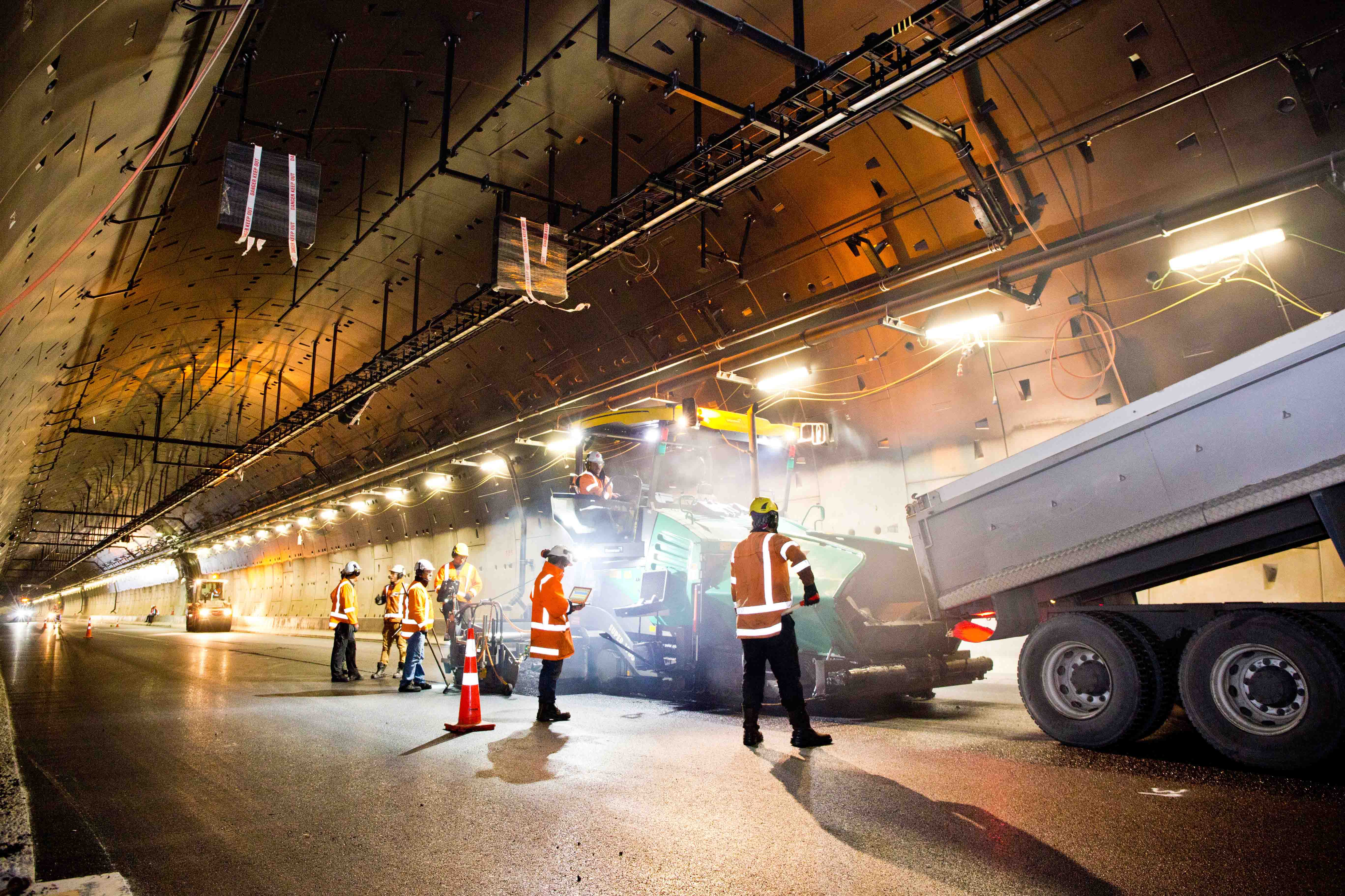
The tunnel features multiple asphalt layers with an SMA surface
New Zealand’s biggest road project is less than a year away from completion, and a lot of progress has been made since World Highways last looked at the project two years ago - Mary Searle Bell reports
New Zealand’s Waterview project is moving closer to completion and will be the largest road project in the country. The NZ$2 billion Western Ring Route will see the creation of an alternative motorway to State Highway 1, which runs through the centre of Auckland. The 47km-long motorway will allow a large portion of passenger traffic and freight to bypass the central business district (CBD), which in turn will ease pressure on SH1 and the Auckland Harbour Bridge, and make travel times more reliable.
Its key projects include raising and widening the causeway across the harbour, and constructing a pair of new tunnels and a spectacular new interchange at the tunnels’ northern portal.
Since it was first constructed in the 1950s the causeway has sunk considerably, which made it prone to flooding during extremely high tides and bad weather.
The upgrade is raising the causeway by up to 2.5m for half its 4.8km length. It is also being widened significantly to allow expansion of the existing dual three-lane motorway. The new configuration will have five lanes heading north and four lanes southbound into the city. There will also be dedicated bus shoulder lanes.
Over 1,500,000tonnes of quarried material has been imported, handled and spread to build up the causeway. The work is being undertaken by the Causeway Alliance, which is made up of1397 AECOM, Coffey, 6191 Fulton Hogan, 2685 Leighton Contractors, Jacobs and the client, the 2574 NZ Transport Agency.
The project has a number of complex challenges which the alliance has had to address. The causeway runs beside the Motu Manawa-Pollen Island Marine Reserve, and the project has had to ensure that it has had little or no impact it. The reserve includes intertidal mudflats, tidal channels, mangrove swamps, salt marshes and shell banks, and is an important feeding ground for a number of wading birds, such as the endangered banded rail, the shy and vulnerable native fernbird, and migratory birds such as godwits and sandpipers, which fly in each summer from Asia.
The mudflats and swamps are, as expected, soft soils, which is why the original causeway sank by up to 2m. The variable, deep, weak subsoil includes Jurassic-period greywacke from 200 million years ago, marine mud that is 25 million years of age, 30,000-year-old basalt from the Mt Albert lava flow and more recent shell banks. The project has been described as building earthworks and a road over material with the consistency of toothpaste.
Dr Daiquan Yang, principal - geotechnical lead, of engineering consultancy Coffey, says the Causeway Upgrade project is one of most challenging projects he has ever been involved in in his 26-year career in Asia, Europe, Australia and New Zealand.
“The level of geotechnical risks, complexities and challenges is found to be far greater than previous other projects. During the tender design phase, many experts from New Zealand and overseas (Australia) were inspired by the geotechnical design team that we were challenging something almost impossible.”
The geotechnical design solution involved the use of 24,000 wick drains, to remove low level pore water from the marine muds to allow consolidation. Preload was used to achieve the required ground strength, as opposed to other solutions such as deep soil mixing and the introduction of cement stabilising, which was a risk next to such a sensitive marine environment.
The various phases of reclamation works included construction of a temporary stability berm allowing the installation of wick drains, a temporary rock cofferdam that protected the site from the sea and the sea from sediments, and construction of the permanent embankment.
Senior project manager Simon Paton told World Highways that the chief engineering challenge was to get the stiffness underneath the new section of causeway the same as the old so that the two behave similarly over time.
However, he says the other major challenge was working in a live motorway corridor with 90,000 vehicles going up and down/day.
“It’s a very confined space and we had to get it 1.5m higher – we weren’t just working on the horizontal but the vertical plane as well,” he said
Numerous traffic reconfigurations have been required to keep the three existing motorway lanes running in both directions during construction. As of September 2016 over 50 major traffic switches had been successfully delivered that enabled the motorway to remain open while it was being upgraded.
“The causeway has horrendous detour routes,” said Paton. “So we had to create work areas without closures.”
In addition, because of its location in the harbour, work has been planned and executed around the tidal cycles.
The cycleway that runs alongside the motorway has 450 daily commuters, and Paton says it was a condition of the contract that it remained open throughout the works. The Causeway Alliance constructed temporary paths, paid close attention to traffic management around cycleway detours and worked closely with cycle interest groups. Consequently, Paton says the team has received “quite a bit of positive feedback” from the cycling community even with all the disruption.
Still ahead of the Causeway Alliance crew are 45 shifts of paving. Paton said that all lanes should be open in their new alignment by October, then the final surfacing will happen. This is scheduled for late spring/early summer. He said an Open Grade Porous Asphalt (OGPA) will be used on the motorway while a Stone Mastic Asphalt (SMA) will be used on the ramps, as it is better able to cope with breaking and accelerating.
“Ideally, we’ll have two pavers working in tandem to get twice as much done in a single night,” said Paton. “The final surfacing should be completed by the end of January.”
A few final pieces of the project following the paving works are inherently linked to the neighbouring Waterview Tunnels project. Things such as signage regarding the tunnels and the Southwestern motorway cannot be installed until the link is about to open.
“There’s been a lot of coordination between the two projects,” said Paton. “It’s fortunate both projects are being delivered as alliances, as alliances have more collaboration anyway.”
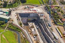
Central to the Waterview Connection are twin tunnels, burrowing beneath the suburbs of Waterview and Owairaka. The Waterview Tunnels will connect the Southwestern and Northwestern motorways and are the missing link that will complete the Western Ring Route. They will also provide a much needed direct route from the CBD to the airport.
Each tunnel will carry three lanes of traffic for 2.4km, up to 40m below the suburbs. When complete, it will be New Zealand’s longest road tunnel.
This project is being undertaken by the Well-Connected Alliance, which comprises the client, NZ Transport Agency, along with Fletcher Construction,2673 McConnell Dowell Constructors, 2671 Beca Infrastructure, Tonkin & Taylor, 2782 WSP 3220 Parsons Brinkerhoff and 2401 Obayashi Corporation. Sub-alliance partners are Spanish tunnel controls specialists SICE NZ (Sociedad Ibérica de Construcciones Eléctricas) and New Zealand pre-cast concrete suppliers 2678 Wilson Tunnelling.
The 87m-long, 3,400tonne tunnel boring machine began work at the end of October 2013 excavating the northbound tunnel, completing the journey 11 months later. The next step was turning the machine 180 degrees so it could dig the second tunnel – a complex project in itself given the constricted space and the size of the tunnel borer. Tunnelling resumed with the southbound tunnel in January 2015 with breakthrough achieved in October.
The statistics on the tunnel borer’s work are impressive, with 792,100m3 of spoil excavated (enough to fill 320 Olympic-size swimming pools), 24,040 concrete segments installed, and 49,000m3 of grout used to fill the gap between the outside ring and the ground.
A five-month-long project to dismantle the borer and ready it for transport and shipping back to its German manufacturer,2592 Herrenknecht, was completed early this year. The 270tonne main drive (its heaviest section) was transported from site to the port on a 48-axle, double width trailer, pulled by three tractor units with a fourth pushing it.
With boring finished and 16 cross passages to link the two tunnels constructed, the excavation work on the project is complete. The cross passages are positioned every 150m and will be used to evacuate people from one tunnel to the other in the event of an emergency. They also house equipment to be used to operate the tunnels.
A programme of work is now underway inside the tunnels to ready them for opening in early next year. It includes the construction of the road surface, installation of concrete linings, lights, drains, deluge safety system and signage, as well as painting the walls and ceilings.
Multiple layers of structural asphalt have been laid inside the tunnel. The final layer of SMA asphalt, covered an area of 209,600m2.
The tunnels will feature state-of-the-art ventilation and monitoring systems to protect the health of users. There are 30 jet fans in one tunnel and 32 in the other to extract fumes. Tunnels and operations manager Emilio Marquez said, depending on traffic levels, up to 14 will be used to extract normal vehicle emissions, but all will be switched on in the event of a fire to control smoke.
Emissions will be dispersed in a controlled manner through 15m-high chimney stacks via ventilation buildings at the exits of each tunnel. Each ventilation building will house four axial fans of 2.5m diameter, with a capacity of 150m3 per second per fan.
The Northern vent stack is ellipse-shaped and will be finished with bronze-coloured steel fins for an architectural finish – the fins wrap around the stack and have a progressive kink fabricated into them to give the illusion of a spiral.
Marquez said that the tunnels will be monitored round the clock by two operators in the Auckland Traffic Operations Centre. They will receive visual information via 130 CCTV cameras covering the whole of the inside of the tunnels. An automatic incident detection system will alert them to things such as stopped vehicles or pedestrians; “an alarm will be raised, kicking off the incident response system,” he explained.
The fire detection system will also have an automatic response and the deluge system should extinguish any fire before it gets too big.
Marquez also said that there are a number of ways to communicate with drivers in the tunnel in the event of an emergency. Along with variable message, speed limit and lane control signs, there will be a public address system. The NZ Transport Agency will also have the ability to break into and broadcast on all local radio stations playing in vehicles in the tunnels.
Like the Causeway Upgrade, this part of the Waterview Connection involved working close to live motorway traffic. Construction manager north Lynne Makepeace says working in the median of the motorway, with large plant, next to high speed traffic was a significant challenge.
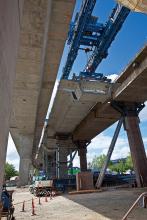
The Great North Road Interchange comprises four ramps that total 1.7km in length. They soar across the motorway on a total of 53 columns, which have all been built on piled foundations. The eight abutments also have piled foundations – four each. All the piles have been sunk into the basalt rock below the surface, some up to 30m deep.
In late May, the 140tonne gantry constructing the Great North Road interchange finished its work placing 277 Super T concrete beams between the columns that support the interchange. Each beam is up to 36m long and weighs up to 70tonnes. Surfacing work on the interchange ramps will be completed during October and November.
There is a whole raft of other work incorporated into the Waterview Connection project, including urban design and landscaping initiatives for the benefit of the neighbouring communities. Namely, a number of walking and recreational facilities including several new parks – from nature reserves and wetlands to playgrounds to skateparks and more – as well as a network of paths and footbridges for pedestrians and cyclists.
The Waterview Connection is New Zealand’s largest ever roading project and the NZ Transport Agency describes it as an enormous task. Project enabling works began in January 2012 at the southern end and construction proper began in June 2012. The project is progressing on schedule and the tunnels and interchange should open in early 2017.
Five other projects are either complete, underway or due to commence to complete the Western Ring Route. These smaller projects include upgrades to several interchanges as well as widening and upgrading the road in places. The route should be fully complete by 2021.
All images courtesy of the New Zealand Transport Agency.
New Zealand’s Waterview project is moving closer to completion and will be the largest road project in the country. The NZ$2 billion Western Ring Route will see the creation of an alternative motorway to State Highway 1, which runs through the centre of Auckland. The 47km-long motorway will allow a large portion of passenger traffic and freight to bypass the central business district (CBD), which in turn will ease pressure on SH1 and the Auckland Harbour Bridge, and make travel times more reliable.
Its key projects include raising and widening the causeway across the harbour, and constructing a pair of new tunnels and a spectacular new interchange at the tunnels’ northern portal.
The Causeway Upgrade project
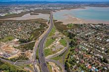
The NZ$220 million Causeway Upgrade Project is vital to the improvement of the city’s road network. The causeway runs across Waitemata Harbour and provides a direct connection between the western suburbs and the rest of the city. This particular section of motorway sees more than 90,000 vehicles/day, along with hundreds of daily users of the cycleway that runs beside it.Since it was first constructed in the 1950s the causeway has sunk considerably, which made it prone to flooding during extremely high tides and bad weather.
The upgrade is raising the causeway by up to 2.5m for half its 4.8km length. It is also being widened significantly to allow expansion of the existing dual three-lane motorway. The new configuration will have five lanes heading north and four lanes southbound into the city. There will also be dedicated bus shoulder lanes.
Over 1,500,000tonnes of quarried material has been imported, handled and spread to build up the causeway. The work is being undertaken by the Causeway Alliance, which is made up of
The project has a number of complex challenges which the alliance has had to address. The causeway runs beside the Motu Manawa-Pollen Island Marine Reserve, and the project has had to ensure that it has had little or no impact it. The reserve includes intertidal mudflats, tidal channels, mangrove swamps, salt marshes and shell banks, and is an important feeding ground for a number of wading birds, such as the endangered banded rail, the shy and vulnerable native fernbird, and migratory birds such as godwits and sandpipers, which fly in each summer from Asia.
The mudflats and swamps are, as expected, soft soils, which is why the original causeway sank by up to 2m. The variable, deep, weak subsoil includes Jurassic-period greywacke from 200 million years ago, marine mud that is 25 million years of age, 30,000-year-old basalt from the Mt Albert lava flow and more recent shell banks. The project has been described as building earthworks and a road over material with the consistency of toothpaste.
Dr Daiquan Yang, principal - geotechnical lead, of engineering consultancy Coffey, says the Causeway Upgrade project is one of most challenging projects he has ever been involved in in his 26-year career in Asia, Europe, Australia and New Zealand.
“The level of geotechnical risks, complexities and challenges is found to be far greater than previous other projects. During the tender design phase, many experts from New Zealand and overseas (Australia) were inspired by the geotechnical design team that we were challenging something almost impossible.”
The geotechnical design solution involved the use of 24,000 wick drains, to remove low level pore water from the marine muds to allow consolidation. Preload was used to achieve the required ground strength, as opposed to other solutions such as deep soil mixing and the introduction of cement stabilising, which was a risk next to such a sensitive marine environment.
The various phases of reclamation works included construction of a temporary stability berm allowing the installation of wick drains, a temporary rock cofferdam that protected the site from the sea and the sea from sediments, and construction of the permanent embankment.
Senior project manager Simon Paton told World Highways that the chief engineering challenge was to get the stiffness underneath the new section of causeway the same as the old so that the two behave similarly over time.
However, he says the other major challenge was working in a live motorway corridor with 90,000 vehicles going up and down/day.
“It’s a very confined space and we had to get it 1.5m higher – we weren’t just working on the horizontal but the vertical plane as well,” he said
Numerous traffic reconfigurations have been required to keep the three existing motorway lanes running in both directions during construction. As of September 2016 over 50 major traffic switches had been successfully delivered that enabled the motorway to remain open while it was being upgraded.
“The causeway has horrendous detour routes,” said Paton. “So we had to create work areas without closures.”
In addition, because of its location in the harbour, work has been planned and executed around the tidal cycles.
The cycleway that runs alongside the motorway has 450 daily commuters, and Paton says it was a condition of the contract that it remained open throughout the works. The Causeway Alliance constructed temporary paths, paid close attention to traffic management around cycleway detours and worked closely with cycle interest groups. Consequently, Paton says the team has received “quite a bit of positive feedback” from the cycling community even with all the disruption.
Still ahead of the Causeway Alliance crew are 45 shifts of paving. Paton said that all lanes should be open in their new alignment by October, then the final surfacing will happen. This is scheduled for late spring/early summer. He said an Open Grade Porous Asphalt (OGPA) will be used on the motorway while a Stone Mastic Asphalt (SMA) will be used on the ramps, as it is better able to cope with breaking and accelerating.
“Ideally, we’ll have two pavers working in tandem to get twice as much done in a single night,” said Paton. “The final surfacing should be completed by the end of January.”
A few final pieces of the project following the paving works are inherently linked to the neighbouring Waterview Tunnels project. Things such as signage regarding the tunnels and the Southwestern motorway cannot be installed until the link is about to open.
“There’s been a lot of coordination between the two projects,” said Paton. “It’s fortunate both projects are being delivered as alliances, as alliances have more collaboration anyway.”
The Waterview Tunnels
The NZ$1.4 billion Waterview Connection will have a huge impact on the city of Auckland. The NZ Transport Agency has called it the most important transport infrastructure project in Auckland in almost 60 years (The Auckland Harbour Bridge, which opened in 1959, similarly unlocked significant parts of the city).Central to the Waterview Connection are twin tunnels, burrowing beneath the suburbs of Waterview and Owairaka. The Waterview Tunnels will connect the Southwestern and Northwestern motorways and are the missing link that will complete the Western Ring Route. They will also provide a much needed direct route from the CBD to the airport.
Each tunnel will carry three lanes of traffic for 2.4km, up to 40m below the suburbs. When complete, it will be New Zealand’s longest road tunnel.
This project is being undertaken by the Well-Connected Alliance, which comprises the client, NZ Transport Agency, along with Fletcher Construction,
The 87m-long, 3,400tonne tunnel boring machine began work at the end of October 2013 excavating the northbound tunnel, completing the journey 11 months later. The next step was turning the machine 180 degrees so it could dig the second tunnel – a complex project in itself given the constricted space and the size of the tunnel borer. Tunnelling resumed with the southbound tunnel in January 2015 with breakthrough achieved in October.
The statistics on the tunnel borer’s work are impressive, with 792,100m3 of spoil excavated (enough to fill 320 Olympic-size swimming pools), 24,040 concrete segments installed, and 49,000m3 of grout used to fill the gap between the outside ring and the ground.
A five-month-long project to dismantle the borer and ready it for transport and shipping back to its German manufacturer,
With boring finished and 16 cross passages to link the two tunnels constructed, the excavation work on the project is complete. The cross passages are positioned every 150m and will be used to evacuate people from one tunnel to the other in the event of an emergency. They also house equipment to be used to operate the tunnels.
A programme of work is now underway inside the tunnels to ready them for opening in early next year. It includes the construction of the road surface, installation of concrete linings, lights, drains, deluge safety system and signage, as well as painting the walls and ceilings.
Multiple layers of structural asphalt have been laid inside the tunnel. The final layer of SMA asphalt, covered an area of 209,600m2.
The tunnels will feature state-of-the-art ventilation and monitoring systems to protect the health of users. There are 30 jet fans in one tunnel and 32 in the other to extract fumes. Tunnels and operations manager Emilio Marquez said, depending on traffic levels, up to 14 will be used to extract normal vehicle emissions, but all will be switched on in the event of a fire to control smoke.
Emissions will be dispersed in a controlled manner through 15m-high chimney stacks via ventilation buildings at the exits of each tunnel. Each ventilation building will house four axial fans of 2.5m diameter, with a capacity of 150m3 per second per fan.
The Northern vent stack is ellipse-shaped and will be finished with bronze-coloured steel fins for an architectural finish – the fins wrap around the stack and have a progressive kink fabricated into them to give the illusion of a spiral.
Marquez said that the tunnels will be monitored round the clock by two operators in the Auckland Traffic Operations Centre. They will receive visual information via 130 CCTV cameras covering the whole of the inside of the tunnels. An automatic incident detection system will alert them to things such as stopped vehicles or pedestrians; “an alarm will be raised, kicking off the incident response system,” he explained.
The fire detection system will also have an automatic response and the deluge system should extinguish any fire before it gets too big.
Marquez also said that there are a number of ways to communicate with drivers in the tunnel in the event of an emergency. Along with variable message, speed limit and lane control signs, there will be a public address system. The NZ Transport Agency will also have the ability to break into and broadcast on all local radio stations playing in vehicles in the tunnels.
The Great North Road interchange
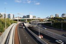
The Waterview Connection project includes construction of a giant interchange near the northern entrance to the tunnels to connect the Northwestern and Southwestern motorways.Like the Causeway Upgrade, this part of the Waterview Connection involved working close to live motorway traffic. Construction manager north Lynne Makepeace says working in the median of the motorway, with large plant, next to high speed traffic was a significant challenge.
The Great North Road Interchange comprises four ramps that total 1.7km in length. They soar across the motorway on a total of 53 columns, which have all been built on piled foundations. The eight abutments also have piled foundations – four each. All the piles have been sunk into the basalt rock below the surface, some up to 30m deep.
In late May, the 140tonne gantry constructing the Great North Road interchange finished its work placing 277 Super T concrete beams between the columns that support the interchange. Each beam is up to 36m long and weighs up to 70tonnes. Surfacing work on the interchange ramps will be completed during October and November.
There is a whole raft of other work incorporated into the Waterview Connection project, including urban design and landscaping initiatives for the benefit of the neighbouring communities. Namely, a number of walking and recreational facilities including several new parks – from nature reserves and wetlands to playgrounds to skateparks and more – as well as a network of paths and footbridges for pedestrians and cyclists.
The Waterview Connection is New Zealand’s largest ever roading project and the NZ Transport Agency describes it as an enormous task. Project enabling works began in January 2012 at the southern end and construction proper began in June 2012. The project is progressing on schedule and the tunnels and interchange should open in early 2017.
Five other projects are either complete, underway or due to commence to complete the Western Ring Route. These smaller projects include upgrades to several interchanges as well as widening and upgrading the road in places. The route should be fully complete by 2021.
All images courtesy of the New Zealand Transport Agency.

