A number of key projects in Auckland, New Zealand will free-up the city’s congested motorway network - Mary Searle reports.Auckland is a sprawling city, home to 1.4 million people, one third of New Zealand’s total population. Until recently, greater Auckland comprised Auckland city, North Shore city over the harbour bridge to the north, Waitakere city to the west and Manukau city to the south. An amalgamation of these various cities’ councils, plus the regional council and three district councils into one,
 and the old Northbound route")
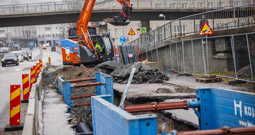
Newmarket - Gantry in Newmarket, lifting the new Northbond segment into place, between the new Southbound Viaduct (left) and the old Northbound route
A number of key projects in Auckland, New Zealand will free-up the city’s congested motorway network - Mary Searle reports.
Auckland is a sprawling city, home to 1.4 million people, one third of New Zealand’s total population. Until recently, greater Auckland comprised Auckland city, North Shore city over the harbour bridge to the north, Waitakere city to the west and Manukau city to the south. An amalgamation of these various cities’ councils, plus the regional council and three district councils into one, was made in late 2010 to facilitate the running of what is now dubbed the Auckland super city.It’s an attractive metropolis stretched out over a rather tricky geography – its centre is on an isthmus, less than 2km wide at its narrowest, between Waitemata Harbour on the Pacific Ocean and Manukau Harbour on the Tasman Sea. Auckland also boasts around 50 extinct volcanoes, and while this all adds to the scenery, it makes building transport routes through the city difficult.
In addition to these challenging characteristics, years and years of underspending by the New Zealand Government on roads and mass transit in the city has meant that in recent times, a substantial amount has had to be spent to bring the road system up to date. In fact, the planning for much of what is being currently undertaken began in 1952!
In late 2010 the government identified seven roads of national significance, or RoNS as they are referred to. The RoNS programme represents one of New Zealand’s biggest ever infrastructure investments, and three of these roads are in Auckland – namely the Victoria Park Tunnel in the central city; the completion of the Western Ring Route, which provides an alternative route to State Highway One between north and south; and Puhoi to Wellsford, north of Auckland, this opens up access to and from Northland and is integral for the region’s growth.
The aim is to have all the RoNS completed by 2020 and the bulk of construction is to begin this year. However, one of these important roads has already been finished.
Thirty years in the planning, the Victoria Park tunnel removes the last major motorway bottleneck between the busy suburb of Newmarket and the Auckland Harbour Bridge. It is the central portion of a 2.4km project built by the Victoria Park Alliance at a cost of NZ$406 million. Around 150,000 motorists use it every day.
The 450m tunnel, which accounted for about a quarter of the total project cost, has three north-bound lanes, meanwhile the existing Victoria Park Viaduct, which used to have two lanes north and two south, has been reconfigured to take traffic southwards on four lanes.
The tunnel construction was by the cut-and-cover method, with the concreted roof being covered with topsoil and developed as an open public space. At its deepest point the motorway floor is 14m below the surface, and 9m below at the portals.
What makes the Vic Park Tunnel innovative in New Zealand is its unprecedented dangerous goods rating, and consequently the tunnel sports a fast-acting fire suppression system. In the event of a fire, sprinkler nozzles deliver a heavy deluge of water - 10mm a minute over each 50m section of the tunnel – quickly suppressing flames, reducing their potential to become severe events.
The pedestrian escape tunnel has 10 doors – eight from the motorway tunnel and two giving access from the portals – while inside there are two sets of escape stairs leading to the surface.
The big-picture engineering that has gone into the Victoria Park Tunnel’s dangerous goods rating is supplemented by a range of sub-systems that include passive fire protection of the roof to limit the temperature exposure to its structural elements, the use of polypropylene fibres within the wall panels to limit the effects of explosive concrete spalling, and fire-sealants in the service penetrations between the tunnel and the service/escape passage.
As a part of the tunnel project, the moveable lane barrier that the Harbour Bridge utilises to manage peak traffic flows has been extended from the bridge to the tunnel exit and CBD on-ramps, allowing the motorway’s capacity to increase from four to five lanes northbound during the evening rush hour to match the traffic flows on the bridge.
Another major central city project that is now largely complete is the new Newmarket Viaduct, which carries State Highway One over this central city suburb.
Undertaken by the NGA Newmarket Alliance, the NZ$215 million project has seen the rather worn, 1960s-built viaduct replaced with one designed and constructed to withstand a one-in-2500-years earthquake. The old viaduct had insufficient capacity during peak hours, resulting in daily traffic congestion. In addition, the structure’s seismic performance was poor by modern standards – parts of the viaduct would have been compromised by even a moderate earthquake – and it had a limited load capacity, forcing heavy trucks to use arterial routes. It also had narrow shoulders, which meant that in the event of an accident, the traffic would back up and emergency services struggled to access the site. On top of all that, the edge barriers were short of modern design standards – a truck actually crashed off the bridge in 2006.
An innovative, staged approach to construction and deconstruction allowed the southbound capacity to be increased in time for the Rugby
The first stage, completed in February 2011, was the construction of the new southbound viaduct. Stage two saw the demolition of the old southbound viaduct to make way for stage three, the northbound side of the new viaduct, which was completed in January this year. Stage four is now underway and involves removing the last of the old bridge. This demolition work is due to be completed in August and the whole project finished by November.
With the pressure easing off Newmarket and Victoria Park, the focus of the city has moved to the next big project: the completion of the Western Ring Route.
Once completed, the Western Ring Route will be a 48km long alternative to State Highway One and the Auckland Harbour Bridge. It splits from State Highway One 20km to the south of the city, bypassing the city to the west, and rejoins it 12km to the north. It encompasses State Highway 20 (the Southwestern Motorway), and State Highways 16 and 18 (the Northwestern Motorway). A fair amount of work has already been completed on the route and much of the rest of it is underway.
A key part of the wider project is the Waterview Connection which will connect the Southwestern and Northwestern Motorways. Waterview will be the largest, most challenging and most expensive project in the upgrade at a cost of NZ$1.4 billion (see World Highways October 2011 interview with Tommy Parker, page 41). Waterview will integrate an extra 4.8km of six-lane motorway through and beneath the city’s Western suburbs. More than half of this new motorway link will be underground.
The project was let to the Well-Connected Alliance in August 2011 as a competitive alliance, one of the biggest in Australasia. At the time of printing, a contract for the custom-built, 15m diameter tunnel boring machine was about to be signed. Designed by
NZTA state highways manager for Auckland and Northland, Tommy Parker, says the project is not all about how fast the tunnel can be delivered as there are other projects which need to be undertaken and completed in conjunction with Waterview to ensure it delivers the benefits required.
“The secret is getting the causeway upgraded,” he said.
The causeway is on State Highway 16, across the Pollen Island Marine Reserve and links the central city with Waitakere city. It has not only been sinking since it was first constructed around 50 years ago, but it also needs to be widened to allow extra lanes of traffic to be added to the route.
Currently the causeway has three lanes of traffic in each direction, plus bus lanes, however, the Waterview tunnel will feed another three lanes onto the causeway and it will ultimately be configured with five lanes heading west and up to five heading into Auckland.
Testing to find the most effective method of raising and widening the causeway is underway at the moment and is scheduled to be completed by the middle of the year.
“The trial is to ensure we get a good idea of the conditions inside the marine reserve and ensure that the construction footprint is as environmentally light as possible,” says Parker.
The NZTA and its contractor,
A cofferdam has been built around the trial area to protect it from tides and to keep the construction area dry while the temporary causeway is constructed. The temporary causeway will sit 1.5m higher than the adjacent motorway until it is eventually absorbed by the main causeway upgrade.
The NZTA has three consortia registered and currently preparing their proposals to undertake the 4.2km long $270 million causeway upgrade project. The construction of this project should begin in late 2013 and be completed at around the same time as the Waterview Tunnel in the first quarter of 2017. Although Parker does say the NZTA is hoping to be able to bring that finish date back to late 2016.
In addition, a number of smaller construction packages on the Northwestern Motorway are also due to be completed in this timeframe, namely to increase capacity at various motorway interchanges and improve traffic flows.
With Newmarket, Victoria Park and Waterview completed, Auckland’s traffic woes will be greatly reduced. All that remains to do in the near future is a few tie-in projects at the northern and southern ends of the motorway. In the north there is currently a bottleneck where State Highway 18 joins State Highway One, and rapid transport in the northwest is still an unknown. Tommy Parker spoke of the possibility of constructing a busway in the northwest that will link in with the Northern Busway.
In the south, extra capacity is required near Manukau, heading south, and continued development in that quarter will necessitate even more.
There is also discussion underway around building another east-west connection between State Highways One and 20 in central Auckland. This is currently a very important freight loop and is evolving as a high priority. The NZTA is setting up an investigation team to look at this and Parker says there will definitely be some development in the next few years.
In the longer-term, plans are underway for a second crossing over the Waitemata Harbour. This is an integral part of the plan for Auckland as ongoing growth continues to put pressure on the Harbour Bridge. In addition, the box girders which allowed an extra four lanes to be added to the bridge in 1969 are ageing. They were strengthened a couple of years ago to prolong their life but will need to be replaced in 30-40 years. However, to do so, a second harbour crossing will need to be operational.
The current draft of the plan shows a tunnel alignment from Victoria Park to Esmond Road on the North Shore. Once this alignment has been confirmed in the Auckland Plan, the NZTA will be putting a team together to progress this. The projected dates for the project are somewhere between 2020 and 2030.
At the far northern reaches of the Auckland motorway more work is scheduled to upgrade the connection to the region of Northland. Between 2005 and 2009 the Northern Motorway was extended 7.5km from Orewa to Puhoi as a toll road. The plan is to further extend the motorway from Puhoi to Wellsford (77km north of Auckland) as a road of national significance. This is due to begin in 2014 and be completed by 2022. Tommy Parker says the NZTA is making good progress on this and will move forward on the design, development and consenting in the next 12 months.
In fact the whole corridor as far north as the city of Whangarei, 160 kilometres north of Auckland, is being looked at. The NZTA considers developing this road, which at the moment has many narrow, winding and hilly sections, will have real benefits for the economic development of Northland.
Dangerous goods explanation
Dangerous goods for transport on land include substances and articles that have explosive, flammable, toxic, infectious, corrosive or environmentally hazardous properties, and containers that have held dangerous goods. All classes of dangerous goods are based on classifications in the United Nations Recommendations on the transport of dangerous goods – model regulations.


 state highways manager for Auckland and Northland detailed the plans for the link")