The use of GPS-inclusive technology is proving invaluable to contractors responsible for major transport-related construction projects across the globe. Guy Woodford looked at some of the latest and imminent site solutions featuring GPS
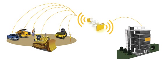
Staff atThe Trimble Connected Office, the Trimble Connected Controller and the Trimble Connected Machine, are all now available to heavy civil construction professionals.
When used together to create the Trimble Connected Site solution, the company has said that time and cost can be saved in the project planning, design, construction and operation process.
“The Trimble Connected Site uses construction technology to improve efficiency and productivity, while minimising waste and expense,” said Roz Buick, vice president and general manager for Trimble’s Heavy Civil Construction Division.
“Trimble solutions empower contractors with site-wide information-integration, and transform the way a contractor gets the job done.”
Trimble has also released the GCS900 Grade Control System version 12.2 with deeper integration into the Connected Site – said to enable real-time updates of design files, reporting of machine usage and monitoring of site progress.
The new version includes Trimble GradeMax technology which, the company has said, significantly increases the overall grading performance of dozers and allows the operator to grade faster, with even more consistency and tighter accuracy.
Meanwhile Topcon’s RTP-300 machine, launched at last month’s
“What is typically used is a car [fitted with road surface profiling technology] that needs to keep stopping when scanning a road surface profile. On larger highways, this has meant the road needs to be closed,” said Achiel Sturm,
“The RTP-300 can scan the road from any vehicle at 105kmh. The highway does not need to be closed and you get clean data. It is way quicker.”
Data collection is achieved by the RTP-300 using a Topcon GNSS (Global Navigation Satellite System) dual-constellation satellite receiver system, three laser profilers, wheel encoder technology and a comprehensive computer data collection system.
The RTP-300 system is also capable of producing industry standard reports such as PRI and IRI.
The corrected design data is said by Topcon to be useable on a paver, profiler or any machine control system to provide exact road data at every step of a construction project.
Canadian company
The Calgary-based firm has said that the Z300 improves grade control accuracy while reducing re-work and the number of required passes.
A further new Hemisphere GPS system is the S320 GNSS Survey Receiver. The model includes SMS communication, GSM auto corrections, GNSS configurability, and SureTrack intelligence.
Hemisphere GPS recently formed a 'strategic alliance' with American firm
“The partnership will help us bring application-centric solutions to the market much faster. The solutions will enhance the complete design-build project lifecycle,” said Randy Noland, vice president of Carlson Software Machine Control.
A number of new product launches resulting from the new Hemisphere GPS–Carlson Software strategic alliance are expected to take place in 2012 and beyond. They will be made available through their respective distribution channels.
"The ProFlex 800 is an ideal solution for customers wanting a single GNSS receiver for multiple applications," said François Erceau, general manager of
Used as a backpack rover or reference station, the ProFlex 800 with Z-Blade technology is also said to be a flexible GNSS solution for land surveying. Its innovative design is said to make it ideal for hard-mounted survey applications such as coastal work, dredging, bathymetry or offshore vessel operations.
The weatherproof, high-impact-resistant molded aluminum housing is said by SP to allow the ProxFlex 800 to operate in harsh conditions.
In addition to a 3.5G internal cellular modem, the ProFlex 800 can use a variety of internal or external UHF modules, providing stable and reliable wireless communications. It can be used as a rover or a base without additional accessories in the field. The ProFlex 800’s Z-Blade long-range RTK capability combined with industry-leading UHF options are said to help ensure maximum productivity while in the field.
With its built-in Ethernet capability and embedded web server, users can access the ProFlex 800 from any computer connected to the Internet. This capability is said to allow instant real-time multi-data streaming over an Ethernet connection to build an RTK corrections server without any additional software or equipment.
The SP ProFlex 800 is also available as a Continuously Operating Reference Station (CORS).This configuration is described as an optimal solution when collecting, storing and transferring high-quality GNSS raw data for post-processing surveys, geodetic and other applications. Automatic sessions programming, a user-friendly web-interface, an embedded RINEX converter, FTP push functionality and many other advanced CORS features are said to make the ProFlex 800 CORS a powerful, robust and easy-to-use GNSS solution.
Z-Blade is a new GNSS-centric signal-processing technology that uses all of the available satellite signals equally, without preference to any particular satellite constellation. This is said to maximise the user’s ability to obtain reliable GNSS positions in tough conditions. Z-Blade allows users to receive and maintain RTK positioning even if GPS coverage is insufficient. In many work locations, just a few GPS and GLONASS satellites may be visible due to obstacles such as trees or buildings.
Due for release in June 2012,
The data collected from the machine and GPS satellites by the Smart Fleet system is transmitted through the mobile networks to the New Holland Telematics Web Portal, where the fleet manager will be able to view the information. Regular updates can be provided about the location of each machine. NH has said that it’s possible to ‘geo-fence’ the machines, with an alert sent out if one is removed from a predetermined area. Unauthorised use of the machines can also be prevented by setting up a working curfew and motion detection service.
New Holland has said that the fleet manager will be able to optimise usage by identifying under- or over-used machines. They will also be able to access the maintenance information of every unit in their fleet from their desk and receive alerts when a machine is due for service. Customers can order the Smart Fleet system from their New Holland dealer and have it retro-fitted to existing machines in their fleet or have it fitted on a new model, which will come pre-wired from the factory.
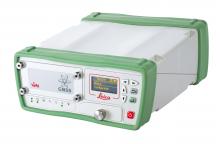
Superior GNSS technology and various integrated communication options are described as key features of the GNSSSmartAntenna. An integrated display shows operators full status information on the system, simplifying operation and configuration. The Leica iCON gps 60 is also able to work with Leica SmartNet and other RTK networks for high-accuracy GPS positioning.
Customer benefits of using the Leica iCON gps 60 include the lack of requirement for a controller for base station set-up, with any corrections streamed over the Internet without radio; and saved time and increased productivity from easily and quickly monitoring the grade from a supervisor vehicle on-site.


