Uganda has unveiled plans for the construction of two road projects considered critical in enhancing the integration of the Eastern African economies and boosting the landlocked country's socio-economic performance - Shem Oirere writes
The new Rukungiri–Kihihi–Ishasha/Kanungu and Bumbobi-Bubulo-Lwakhakha roads in Uganda feature a design influenced by the desire to harmonise modern road standards in East Africa. These new links will also cater for the current acute shortage of gravel for road construction

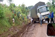
The improved road will provide a better connection through Uganda, linking the country with its neighbours
Uganda has unveiled plans for the construction of two road projects considered critical in enhancing the integration of the Eastern African economies and boosting the landlocked country's socio-economic performance - Shem Oirere writes
The new Rukungiri–Kihihi–Ishasha/Kanungu and Bumbobi-Bubulo-Lwakhakha roads in Uganda feature a design influenced by the desire to harmonise modern road standards in East Africa. These new links will also cater for the current acute shortage of gravel for road construction, have a combined distance of 124km and will open up Uganda to its neighbours of Democratic Republic of Congo (DRC) and Kenya, enhancing the flow of goods in and out of the country.
1069 Uganda National Roads Authority (UNRA) wants to improve the existing Rukungiri–Kihihi–Ishasha/Kanungu gravel road in the south-western part of the country so that it features an asphalt surface. The road traverses the districts of Rukungiri and Kanungu before terminating at the border town of Ishasha on the Uganda/DRC border.
UNRA says the road will also provide tourists with easier access to the 1,978km2 Queen Elizabeth National Park, Uganda’s most visited tourist attraction and famous for its volcanic features such as volcanic cones and deep craters, many with crater lakes such as Lake Katwe where salt is extracted.
A project brief on the road, which is being partially funded by the1586 African Development Bank (AfDB), shows that a section of the existing road passes through the Queen Elizabeth National Park but under the new project the park has been avoided with a 17km new alignment from Nyakashure to Ishasha on the border. The road will provide will also provide an alternative route for international traffic to DRC and other countries such as Rwanda, Burundi and Zambia.
Phase one of the road project entails asphalting of the 52km stretch between Rukungiri to Ishasha while the second phase involves the 27km stretch linking Kihihi to Kanungu, both linking to the paved section of Ntungamo-Rukungiri road, a regional and international link to DRC. An initial proposal to have the road re-gravelled as the cheaper option, rather than upgrading it with an asphalt surface, was discarded because of the anticipated maintenance costs during or after rainy seasons and the environmental cost of obtaining gravel.
“Additionally, this option has a host of attendant environmental and social concerns such as land uptake for borrow areas, landscape/ scenic blight due to borrow pits, erosion and siltation of water bodies, and dust nuisance to the road users and the public,” explained UNRA.
The road project will consume an estimated 61,000m3 of gravel and 5,061,544m3 of aggregate in addition to lime, bitumen, water, cement and steel especially for the four river crossing structures.
And according to Amadou Oumarou, director for Transport and Information and Communication Technologies at the AfDB the road project, “…will also help alleviate challenges faced by women such as reduction in travel time in cases of emergency.”
“Most importantly, the reduction in travel time will enable emergency cases, including those related to maternity cases, reach health facilities in a timely manner, with the expected 20% reduction in a number of maternity emergencies.”
Uganda is also pushing to integrate its road network with regional and international links passing through Kenya with the asphalting of the 44.8km Bumbobi-Bubulo-Lwakhakha road.
This road project has been split into three phases including Bumbobi-Bubulo (15km), Bubulo-Busumbu (15km) and Busumbu-Lwakhakha (14km). A project brief by UNRA says the road alignment follows the existing Bumbobi-Bubulo-Lwakhakha gravel road from Bumbobi Trading Centre to Lwakhakha Township on the Kenya Uganda border, becoming a major link between the two countries and the Kampala-Gulu-Juba corridor.
It is also expected to decongest the existing Uganda-Kenya border posts of Busia and Malaba. More than 95% of Uganda exports and imports pass through Kenya’s port of Mombasa with 90% of the cargo being moved by road and only 10% by rail.
The engineering design shows that both roads will be 10m wide with a 7m carriageway and paved shoulders on either side of the road, each 1.5m in the rural area and 2m wide in trading centres. In addition, the roads will have an extra 3.5m wide parking lane in built-up areas, while in some stretches the roads will require widening.
The contractor will need to extend all the existing culverts in addition to replacing headwalls. The extended culverts will all be more than 900mm for easy maintenance. Four bridges will be constructed: Rukungiri-Kihihi-Ishasha/Kanungu Road at Kakinada Stream; River Ntungu; Kiruruma; and Ishasha. The Bumbobi-Bubulo–Lwakhakha road is also expected to have at least four river crossings of similar design with those for Rukungiri-Kihihi-Ishasha/Kanungu Road.
Modernisation of transport infrastructure along this corridor is critical for trade expansion and economic growth, which are key to the success of regional integration, creation of wealth, and poverty alleviation in these countries,” said UNRA.
The new Rukungiri–Kihihi–Ishasha/Kanungu and Bumbobi-Bubulo-Lwakhakha roads in Uganda feature a design influenced by the desire to harmonise modern road standards in East Africa. These new links will also cater for the current acute shortage of gravel for road construction, have a combined distance of 124km and will open up Uganda to its neighbours of Democratic Republic of Congo (DRC) and Kenya, enhancing the flow of goods in and out of the country.
UNRA says the road will also provide tourists with easier access to the 1,978km2 Queen Elizabeth National Park, Uganda’s most visited tourist attraction and famous for its volcanic features such as volcanic cones and deep craters, many with crater lakes such as Lake Katwe where salt is extracted.
A project brief on the road, which is being partially funded by the
Phase one of the road project entails asphalting of the 52km stretch between Rukungiri to Ishasha while the second phase involves the 27km stretch linking Kihihi to Kanungu, both linking to the paved section of Ntungamo-Rukungiri road, a regional and international link to DRC. An initial proposal to have the road re-gravelled as the cheaper option, rather than upgrading it with an asphalt surface, was discarded because of the anticipated maintenance costs during or after rainy seasons and the environmental cost of obtaining gravel.
“Additionally, this option has a host of attendant environmental and social concerns such as land uptake for borrow areas, landscape/ scenic blight due to borrow pits, erosion and siltation of water bodies, and dust nuisance to the road users and the public,” explained UNRA.
The road project will consume an estimated 61,000m3 of gravel and 5,061,544m3 of aggregate in addition to lime, bitumen, water, cement and steel especially for the four river crossing structures.
And according to Amadou Oumarou, director for Transport and Information and Communication Technologies at the AfDB the road project, “…will also help alleviate challenges faced by women such as reduction in travel time in cases of emergency.”
“Most importantly, the reduction in travel time will enable emergency cases, including those related to maternity cases, reach health facilities in a timely manner, with the expected 20% reduction in a number of maternity emergencies.”
Uganda is also pushing to integrate its road network with regional and international links passing through Kenya with the asphalting of the 44.8km Bumbobi-Bubulo-Lwakhakha road.
This road project has been split into three phases including Bumbobi-Bubulo (15km), Bubulo-Busumbu (15km) and Busumbu-Lwakhakha (14km). A project brief by UNRA says the road alignment follows the existing Bumbobi-Bubulo-Lwakhakha gravel road from Bumbobi Trading Centre to Lwakhakha Township on the Kenya Uganda border, becoming a major link between the two countries and the Kampala-Gulu-Juba corridor.
It is also expected to decongest the existing Uganda-Kenya border posts of Busia and Malaba. More than 95% of Uganda exports and imports pass through Kenya’s port of Mombasa with 90% of the cargo being moved by road and only 10% by rail.
The engineering design shows that both roads will be 10m wide with a 7m carriageway and paved shoulders on either side of the road, each 1.5m in the rural area and 2m wide in trading centres. In addition, the roads will have an extra 3.5m wide parking lane in built-up areas, while in some stretches the roads will require widening.
The contractor will need to extend all the existing culverts in addition to replacing headwalls. The extended culverts will all be more than 900mm for easy maintenance. Four bridges will be constructed: Rukungiri-Kihihi-Ishasha/Kanungu Road at Kakinada Stream; River Ntungu; Kiruruma; and Ishasha. The Bumbobi-Bubulo–Lwakhakha road is also expected to have at least four river crossings of similar design with those for Rukungiri-Kihihi-Ishasha/Kanungu Road.
Modernisation of transport infrastructure along this corridor is critical for trade expansion and economic growth, which are key to the success of regional integration, creation of wealth, and poverty alleviation in these countries,” said UNRA.