The Marc Basnight Bridge in North Carolina won a prestigious award for engineering excellence recently. The structure is 4.51km in length, spans the Oregon Inlet and is replacing the Herbert C Bonner Bridge, which is being demolished. This new bridge won the Deep Foundation Institute’s Outstanding Project Award due to the novel foundation design and construction techniques developed specifically for the project.
The bridge provides a key hurricane evacuation route and plays an important role for North Carolina’s tourism sector. It has been named after Marc Basnight, a Democratic member of the North Carolina State Senate, who represented the 1st District, from 1984 through to his resignation due to ill health in 2011.
Spanning the Oregon Inlet, the bridge connects Hatteras Island with Bodie Island, crossing a channel that is notoriously dangerous. The location provided a particular challenge to the design and construction team as this channel is one of the most treacherous on the eastern seaboard of the US. To cope with the conditions, the bridge has been designed to withstand severe scour, as well as the ferocious storms that can pummel the area.
Environmental aspects further added to the complexity of the work, owing to the location within the Cape Hatteras National Seashore as well as the Pea Island National Wildlife Refuge.
The need for a new bridge had become pressing in recent times and the
From the start it had been clear than the new bridge would require an innovative support structure to cope with the fierce scour that had resulted in the earlier bridge needing regular maintenance and repairs.
“Throughout this project, I’ve told people that the replacement of the Bonner Bridge isn’t a bridge job; it’s a complex marine foundation job with a bridge stuck on top,” explained Domenic Coletti, HDR design manager for the project. “The foundations were the key to the entire project.”
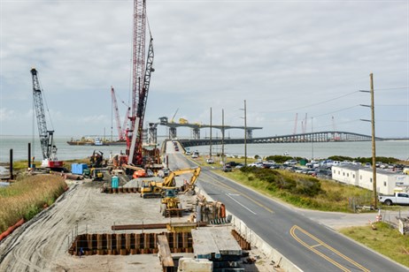
The new bridge has been designed to provide a 100-year service life and to cope with unprecedented scour depths. At the same time, the bridge is intended to minimise environmental impacts while offering a dependable route for drivers. HDR carried out the design work for the roadway, geotechnical factors and bridge, as well as delivering the environmental permitting services for the project.
“For many years, the potential scour design challenges have been known,” explained HDR geotechnical engineer Brian Keaney. “However, through a lot of hard work and our understanding of the subsurface conditions, our geotechnical team pioneered innovative pile verification methods that NCDOT and the design-builder accepted to solve this unique problem.”
According to the hydraulic report for the bridge, “The Advanced CIRCulation Model for Coastal Ocean Hydrodynamics (ADCIRC) program simulated both the tidal circulation and the hurricane storm surges in the project area. ADCIRC is a numerical model developed specifically for generating long duration hydrodynamic circulation along shelves, coasts, and within estuaries. The intent of the model is to produce numerical simulations for very large computational domains in a unified and systematic manner. The collaboration of many researchers have led to the development of the ADCIRC model.”
“The program SWAN (Simulating Waves Nearshore) simulated wave heights and periods. SWAN, developed at the
Coletti explained that the Oregon Inlet changes constantly due to the loose sandy material of the channel, coupled with the constant movement of the water in and out of the inlet, as well as storms.
The team devised an innovative method for determining scour depths, so as to work out the optimum pile lengths for the project. Under normal conditions, the ambient bed elevation for design purposes was assumed to be around 12.2m below mean high water. However, during the most extreme storms, the calculations showed the deepest total scour depths to reach nearly 26m below mean high water in a region near the centre of the bridge.
To cope with the conditions, the team from HDR delivered an innovative bridge foundation design that used a combination of jetting and driving to install precast, prestressed concrete piles. In total, the bridge rests on 690 piles, measuring more than 24km in length. These piles and precast pile caps as well as the precast deck sections and other precast components were all fabricated offsite at a precasting yard in Chesapeake, Virginia and were transported to the project site by truck or barge, depending on their location along the bridge.
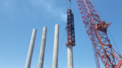
Two main types of foundation systems were used to support the Basnight Bridge. The low-level approach span regions of the bridge, with less scour and lower risks of ship impacts, are supported by foundations with three or four vertical, 1.37m diameter, precast, prestressed concrete cylinder piles that extend up to precast concrete pier caps. This design avoided the need for constructing waterline footings or cofferdams. The pier caps for the cylinder pile bents are located around 6.1m above mean high water. The precast cylinder piles and the precast pier caps were connected by a stainless steel reinforcing bar cage encased in cast-in-place concrete, placed in voids in the piles and pier caps.
However, HDR used a more complex design for the transition spans and the high level, long span navigational spans of the bridge. These areas feature cast-in-place concrete waterline pile caps with six to 30 precast, prestressed concrete piles that provide lateral resistance against wind and ship impact loads under deeper scour conditions.
The builders used a combination of jetting and impact driving to install the piles. PCL used a pile template system to install the prestressed concrete piles used for the transition spans and the high level navigation spans. Temporary steel casings were vibrated into position and excavated using an airlift, with the piles then being jetted to most of the depth, with a piling hammer driving the piles to their required depth. This avoided the need for a more costly system using upper and lower pile templates. For the overland and shallow water regions, steel casings were similarly installed and excavated except that, due to environmental constraints, the material inside these casings was excavated with a large clamshell. The prestressed piles were then installed using an impact hammer. To meet environmental regulations, the spoil was taken to the nearby barrier island to be used to build up sand dunes.
HDR said that the waterline pile caps were formed by first installing the piles, then suspending precast concrete soffit forms from the tops of the piles. This then allowed the piles to be embedded 102cm into the completed pile caps. Once the soffit forms were in place, prefabricated metal side forms were attached and sealed, and the inside of each form was dewatered. Next, stainless steel reinforcing bars were placed inside the forms, along with the lower anchorages of the stainless steel vertical post-tensioning for the columns. Finally, the cast-in-place concrete was placed and due to the size of the pile caps, temperature control and cooling was used for the concrete.
The pile foundations were driven using a fleet of three conventional Pileco D-180 diesel impact hammers. HDR’s Beth Howey, senior geotechnical project manager for the Basnight Bridge explained that the diesel units were considered the most suitable machines for the job for a number of key reasons. Firstly, the diesel units are simpler and more durable in the corrosive marine environment than modern hydraulic rigs, which would have required more maintenance. Secondly, the hydraulic rigs tend to be heavier, a concern given the limits on the loads that could be carried by the barges. Thirdly, and most importantly, the diesel units offer a greater stroke length than the hydraulic units, a crucial factor given the need to, “…transfer enough energy to the pile tips to install them deep enough into the dense sand present,” as she explained.
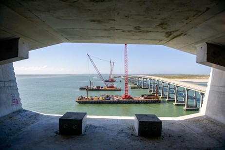
For some of the shallower areas, the piling hammers were fitted to crawler cranes that moved along the temporary trestles. For the deep water areas, the piling hammers were fitted to cranes operating on barges.
The depth to which the piles were driven was crucial for the long-term structural integrity of the bridge. Modelling of the behaviour of the sea using the ADCIRC program had highlighted the potential severity of the scour. Coletti explained that for pile foundations like those used to support the Basnight Bridge, deeper scour equates to the piles having less embedment into the soil and having greater unsupported length, reducing the strength of the foundations from both structural and geotechnical perspectives. As a result, the piles for the most difficult section of the bridge were driven to nearly 43m to provide sufficient structural support even when exposed by scour to depths of nearly 26m.
The deck of the structure is more conventional according to HDR. The superstructure features a combination of precast, post-tensioned, segmental concrete box girders in some spans, and precast, prestressed Florida I-Beam (FIB) girders. The entire 4.5km length of the bridge has 3.66m lanes in either direction and 2.44m shoulders on each side.
Most of the bridge, including the North and South Approach Spans and the North and South Transition Spans, features a conventionally-formed CIP lightweight concrete deck. This rests on precast, prestressed concrete FIB girders. The CIP concrete deck is a conventional design with stainless steel reinforcing.
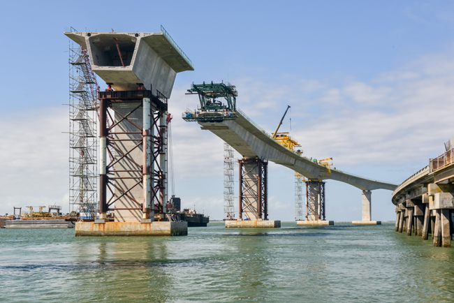
The remaining 1.1km navigation section has 11 spans, with nine measuring 107m and two end spans of 61m. It has a post-tensioned, concrete segmental structure. This is made up of 264 single-cell precast box girder units supported on post-tensioned, precast concrete columns. These precast units have an integral concrete running surface. However, it is worth noting that the designers have included the potential for the provision of an overlay running surface in their calculations, should this be required.
The segments were transported by barge to the site from the casting facility in Virgina. According to HDR, using precast sections improved quality and shortened overall construction time as these could be made while the bridge supports structure was being built.
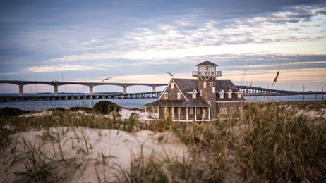
Onsite the segments were raised into position using lifters mounted on the decks. The joints were prepared with an epoxy, with each segment then being secured to the one already attached with temporary post-tensioning bars. Once the epoxy had set, cantilever tendons were installed and the process was then repeated. When the cantilever sections were complete, a concrete closure segment was installed, with bottom slab continuity tendons being inserted to finalise the structure.
The segments varied in weight, with the heaviest being for the pier superstructures. Split segments were used to make it easier to move these larger components.
Meanwhile, the engineering and contracting team also faced the challenge of meeting tough environmental requirements, in particular for the Pea Island National Wildlife Refuge and the Cape Hatteras National Seashore. The team worked closely with the regulatory agencies, using meetings to explain the bridge design and construction process to agency staff. The regulators were able to ask questions and offer feedback. This proactive, partnering approach to the design, permitting, and construction process allowed the permits to be obtained on schedule and for construction to proceed smoothly.
The need for a replacement
The Herbert C Bonner Bridge connecting the islands opened to traffic in 1963, carrying the NC12 road link. This 3.92km dual lane bridge replaced the ferries that had served the islands previously, providing a continuous traffic connection and carrying up to 7,000 vehicles/day. It was named after Herbert C Bonner (1891-1965), a Democratic US Congressman from North Carolina between 1940 and 1965.
However, when this earlier structure was built, the effects of the area’s frequent storms and tidal flow were not well understood and its design and construction were not up to the task. As a result, the bridge suffered from severe scour and its condition deteriorated quickly due to the unforgiving marine environment. It required almost constant maintenance, repair and retrofitting by the North Carolina Department of Transportation (NCDOT).
The bridge suffered a major blow in 1990 when it was struck by a vessel during a storm and it was subsequently closed for a number of weeks so that the authorities could carry out vital repairs.
In all, around $50 million was spent on maintenance work from 1987 to 1999 to ensure that the bridge was of a sufficient standard to cope with the traffic load from residents and visitors. Despite the maintenance, it was recognised that the Herbert C Bonner Bridge was faring poorly and it was not considered to be in an adequate condition to cope with demand. An assessment by NCDOT rated the old bridge’s condition at an alarming 2 out 100 for safety.
The Herbert C Bonner Bridge ended up being used for more than 55 years, despite having been only been intended to last 30 years. Its replacement was first suggested in the 1990s, but questions over the environmental impact of a new bridge meant that plans to start construction work for its replacement were delayed. In late 2013 concern over scour around some of its supports again resulted in the old bridge having to be closed for a number of weeks to carry out emergency repairs.
The old Herbert C Bonner bridge is being dismantled, with some of its remains being used offshore to provide an artificial marine habitat. A portion of the old bridge will also be left for use by pedestrians and for fishing.


