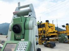
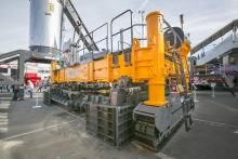
Leica Geosystems has launched v3.0 of its Leica PaveSmart 3D system, which is designed specifically for concrete and asphalt paving and milling applications. This upgraded package is now said to support a wider range of paving equipment and applications than before. PaveSmart 3D v3.0 will be available late March 2012 through Leica Geosystems’ direct sales and approved paving solution distribution channels, including GOMACO.

The sophisticated paving control package from Leica Geosystems is also offered through GOMACO due to its partnership with the firm
Designed specifically for paving contractors, PaveSmart 3D v3.0 offers all-track grade and steering for slipform and roller-compacted concrete paving and placing. It can also be used in asphalt paving and milling, fine-grade trimming and surface mining applications. With operators in mind, PaveSmart 3D v3.0 is said to offer advances in ease of use, 3D design capabilities, setup and configuration for multiple pieces of equipment to make field crews more productive and self-managing.
This system helps maintain flexible jobsite layouts and improve jobsite logistics and operate easier in challenging jobsite environments such as narrow-width, urban and underground projects. The PaveSmart 3D system tracks the position of the paving machine in real-time, in relation to a 3D model of the jobsite, automatically regulating steer and elevation hydraulics to produce the finished concrete or asphalt product directly from the original 3D designs.
Using Leica Geosystems’ robotic total stations and GPS, Leica PaveSmart 3D v3.0 extends Leica Geosystems’ X-Function data modelling and sharing concept to contracting. Job design data can be generated at the start of the project, then can be shared between any CAD system, and Leica Geosystems’ surveying and machine control equipment on the jobsite. PaveSmart 3D v3.0 is the result of 13 years research, development and client satisfaction on hundreds of high-profile infrastructure projects worldwide.


