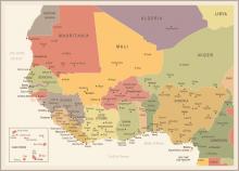
A US$2 billion highway is planned for Nigeria, connecting Lagos with Calabar. The project is expected to take eight years to complete. The route will link Lagos, in the South West of Nigeria and close to its border with Benin, with Calabar in the South East of the country, close to its border with Cameroon.
The alignment has yet to be finalised but the route is expected to be 640-696km in length. The two cities are around 570km apart by air, while the existing road route between the two is around 760km and typically takes 10 hours. Building the new road will reduce journey times between Lagos and Calabar considerably and the new route will include some existing highway stretches. The new highway will likely connect with the large city of Onitsha, another major centre for trade in Nigeria. The route will also improve transport connections to the city of Port Harcourt in South East Nigeria, which is the focus for the country's oil industry.
Although the alignment of the route has yet to be announced, it seems likely that it will follow much of the existing roads between the cities. In Nigeria’s South East, it is likely to pass close to the current main route via Ikot Ekpene, before heading southwards towards Calabar. While a more southerly route passing Uyo would be shorter, this would require the construction of bridges spanning Cross River at considerably more expense.
The work will be carried out in a series of stages. The first stage of the project will be carried out in the Lagos area, connecting Ahmadu Bello Way Victoria Island to Lekki, with the work being handled by Hitech Construction Africa.


